

maps.pchgl.org
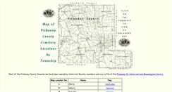
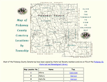
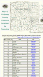
Map of Pickaway County (Ohio) Cemetery Locations by TownshipIndividual township maps noting cemetery locations and names, as well as county and township roads.
http://maps.pchgl.org/
Individual township maps noting cemetery locations and names, as well as county and township roads.
http://maps.pchgl.org/
TODAY'S RATING
>1,000,000
Date Range
HIGHEST TRAFFIC ON
Tuesday
LOAD TIME
0.2 seconds
16x16
32x32
PAGES IN
THIS WEBSITE
15
SSL
EXTERNAL LINKS
0
SITE IP
76.181.173.187
LOAD TIME
0.195 sec
SCORE
6.2
Map of Pickaway County (Ohio) Cemetery Locations by Township | maps.pchgl.org Reviews
https://maps.pchgl.org
Individual township maps noting cemetery locations and names, as well as county and township roads.
 maps.pchgl.org
Pickaway Co. Township Map - Perry Twp.
http://maps.pchgl.org/pert.htm
Perry Township, Pickaway County, Ohio. See Chart Below for names of the Cemeteries. Map and Research done by Ralph and Charlene Woolever. Graciously donated by them for this website. They have also. Posted a copy of the map at the Pickaway Co. Genealogical Library. Cemetery locations were marked on this map according to maps in the County Recorder's Office which were drawn up by W.P.A. workers in the 1930's. 500 ft. South C-27; .2 m West C-18. West side T-18; .5 m North T-25. 1500 ft. East S.R...4 m N...
Pickaway Co. Township Map - Circleville Twp.
http://maps.pchgl.org/cirt.htm
Circleville Township, Pickaway County, Ohio. See Chart Below for names of the Cemeteries. Map and Research done by Ralph and Charlene Woolever. Graciously donated by them for this website. They have also. Posted a copy of the map at the Pickaway Co. Genealogical Library. Cemetery locations were marked on this map according to maps in the County Recorder's Office which were drawn up by W.P.A. workers in the 1930's. West side T-38; 1 m North C-4. North side of East High St. East of Pickaway St. Pickaway Co...
Pickaway Co. Township Map - Wayne Twp.
http://maps.pchgl.org/waynt.htm
Wayne Township, Pickaway County, Ohio. See Chart Below for names of the Cemeteries. Map and Research done by Ralph and Charlene Woolever. Graciously donated by them for this website. They have also. Posted a copy of the map at the Pickaway Co. Genealogical Library. Cemetery locations were marked on this map according to maps in the County Recorder's Office which were drawn up by W.P.A. workers in the 1930's. 200' West S.R. 104; .2 m South T-101. 9 m West S.R. 104; .3 m North T-103. West side S.R....Retur...
Pickaway Co. Township Map - Muhlenberg Twp.
http://maps.pchgl.org/muhlt.htm
Muhlenberg Township, Pickaway County, Ohio. See Chart Below for names of the Cemeteries. Map and Research done by Ralph and Charlene Woolever. Graciously donated by them for this website. They have also. Posted a copy of the map at the Pickaway Co. Genealogical Library. Cemetery locations were marked on this map according to maps in the County Recorder's Office which were drawn up by W.P.A. workers in the 1930's. 2 m North T-191; 1 m West C-6. West side C-3; .5 m South of Darbyville. 13 m North S.R&#...
Pickaway Co. Township Map - Jackson Twp.
http://maps.pchgl.org/jact.htm
Jackson Township, Pickaway County, Ohio. See Chart Below for names of the Cemeteries. Map and Research done by Ralph and Charlene Woolever. Graciously donated by them for this website. They have also. Posted a copy of the map at the Pickaway Co. Genealogical Library. Cemetery locations were marked on this map according to maps in the County Recorder's Office which were drawn up by W.P.A. workers in the 1930's. 1320 ft. East S.R. 104; 1.9 m South S.R. 316. SR 56; 1 m West S.R. 104. 3 m North C-3; .6 m...
TOTAL PAGES IN THIS WEBSITE
15
Interaktive Karte Partschins
IIS Windows Server
Passauer Land
Eyewitness Maps
PBase Maps
Map of Pickaway County (Ohio) Cemetery Locations by Township
Most of the Pickaway County Cemeteries have been copied by Historical Society members and are on file at the Pickaway Co. Historical and Genealogical Library. Borror, Jam. Farm. Brinker, B. Farm. Brinker, C.F. Farm. Calls, Joe Farm. Cromley, Wm. Farm. Doner, Elmer Farm. Dunlap, Arthur Farm. Duvall, A.R. Graffis, John Farm. Hall, Bill Farm. Horn, E. D. Farm. Hott (Geo.) Farm. Montelius Farm or Bald Knot. Praire View (Mound Hill). Reed, Wm. Farm. Rife (Geo.) Farm. Seitz Farm / Brown Family.
Peachtree City Public Maps
PeepDB Maps - People Maps - Reverse Address Search
PeepDB Maps Reverse Address Lookup. Enter an address or right click anywhere on the map to see who lives there.
Peeplo Maps
We use cookies from third parties also to ensure we show you advertising that is relevant to you. If you want to know more or if you want to deny your consent to all or some of the cookies, click here. By closing this banner, scrolling down the page or by clicking any element you agree to our use of cookies. Your website and blogs. Share your post on. Try the App now! Resume advice and tips. For your career planning. For all kinds of micro-publishers. To help you search for and go in-depth on a subject.
Store Locator
Enter your address or zip code. What type of Pella. Retailer are you looking for? Check all that apply:. The Pella Window and Door Store. Lowe's Home Improvement Center ( learn more. Retail Home Centers ( learn more. Lumberyards and Dealers ( learn more. RANGE] miles ( get directions.
Interactive Mapping - Pembrokeshire County Council
Search our A-Z of Services.